
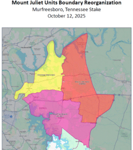
New Mt. Juliet Unit Boundaries Verbal Descriptions
Sacrament Meeting Schedules
– Mount Juliet – 9:00 am – 11:00 am
– Percy Priest – 10:30 am – 12:30 pm
– Hermitage – 12:00 pm – 2:00 pm
– Buena Vista – 1:30 pm – 3:30 pm
Youth Night Schedules
– Tuesday – Mount Juliet and Buena Vista
– Wednesday – Percy Priest
– Thursday – Hermitage
Hermitage Ward (new) – 12:00 pm – 2:00 pm
Start:
– Intersection of US 70 (Lebanon Rd) & TN 171 (N Mt. Juliet Rd)
– South to Old Lebanon Dirt Rd
– West to the Nashville & Eastern Railroad tracks (just west of Andrew Jackson Parkway)
– Follow RR tracks west/southwest to the Stones River
– Follow Stones River north to the Cumberland River
– Follow the Cumberland River north to turn in stake boundary — roughly circling west and north of Hermitage Ridge community until intersecting with the northernmost point of Butler Lane
– East/southeast to TN 45 (Old Hickory Blvd)
– South to Rachels Lane
– East to US 70 (Lebanon Pike)
– Northeast to Shute Lane
– Straight north to the Cumberland River
– Follow the Cumberland River east to Cedar Creek
– Follow Cedar Creek south to US 70 (Lebanon Rd)
– West to beginning point
Mt. Juliet Ward – 9:00 am – 11:00 am
Start:
– Intersection of US 70 (Lebanon Rd) & TN 171 (N Mt. Juliet Rd)
– East to Cedar Creek
– Follow Cedar Creek north to the Cumberland River
– Follow the Cumberland River eastward to TN 109 (S. Water Ave)
– South past US 70 to I-40
– East to I-840
– South to Stewarts Ferry Pike
– West to Harkreader Rd
– North and west and north to Central Pike
– West to Beckwith Rd
– North to S. Rutland Rd
– West to Sunnymeade Drive
– Northwest to Belinda Parkway
– West to merge into Providence Way
– West to TN 171 (S. Mt. Juliet Rd/N. Mt. Juliet Rd)
– North to beginning point
Percy Priest Branch – 10:30 am – 12:30 pm
Start:
– Intersection of TN 171 (S. Mt. Juliet Rd/N. Mt. Juliet Rd) & Providence Way
– East to merge into Belinda Parkway
– East to Sunnymeade Drive
– Southeast to to S. Rutland Rd
– East to Beckwith Rd
– South to Central Pike
– East to Harkreader Rd
– South and east and south to Stewarts Ferry Pike
– East to I-840
– South to Wilson County Line (point just north of Hurricane Creek)
– Follow Wilson/Rutherford county line northwest (continue across Maddox Rd to Rockdale
– Fellowship Rd to Couchville Pike along Couchville Pike and then northwest) to boundary with Davidson County
– South along the Davidson/Rutherford counties line to the Stones River/Percy Priest Lake
– Follow east shore of Percy Priest Lake north to the Percy Priest dam
– North along the Stones River to the Nashville & Eastern Railroad tracks
– Follow RR tracks east/northeast to Old Lebanon Dirt Rd
– East all the way to TN 171 (N Mt. Juliet Rd)
– South to beginning point